Winter Cyclone Dynamics and Precipitation Generating Cells
My Google Scholar Page Back to Research Homepage
The Profiling of Winter Storms (PLOWS) campaign resulted in substantial improvement in the understanding of precipitation substructures within the comma-head of continental winter cyclones. Observed substructures included the ubiquitous presence of shallow cloud-top convective cells termed generating cells (GCs), from which precipitation fallstreaks emanate and seed the underlying deep nimbostratus cloud deck. The project I led within PLOWS assessed the roles of radiation, instability, and environmental shear on the development, maintenance, and organization of GCs through idealized Weather Research and Forecasting (WRF) model Large Eddy Simulations (LES). During an Advanced Study Program Fellowship at the NCAR Research Applications Laboratory, I developed novel methodology to conduct these simulations through collaboration with scientists in the NCAR Hydrometeorological Applications Program. This parameter study established the critical role of cloud-top longwave radiative cooling in the development of instability and resultant convection – even under initially stable cloud-top conditions, and maintenance of convection under initially unstable conditions. When paired with analysis of radar and in situ microphysical data from PLOWS, my research provides a new framework for understanding the development of snowfall under a wide range of upper-tropospheric conditions. These results are highlighted in Keeler et al. 2016 (Parts I and II), and Keeler et al. 2017 (Part III). My collaborative work in this area includes investigations of stability and charging mechanisms in midlatitude winter cyclones (Rauber et. al 2014a), the role of airstreams in organizing precipitation structure in the cyclone comma-head (Rauber et. al 2014b), the roles of generating cells and boundary layer circulations in fine-scale precipication structures (Rauber et. al 2015b), and the development of elevated potential instability (Rosenow et. al 2018).
My ongoing interests in this area relate to turbulence, icing, implications of generating cells on the intensity of precipitation at the surface, and determining how to best parameterize shallow, elevated convection.
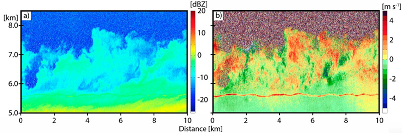
Example of generating cells as observed by W-band radar on 15 February 2010 (Figure 3 from Keeler et al. 2016 Part I). a) Unthresholded Wyoming Cloud Radar (WCR) equivalent reflectivity (dBZe) between 5.0- and 8.5-km altitude for 0709:20-0710:45 UTC. b) Unthresholded WCR vertical radial velocity (m s-1) for the same time period and altitude range. The thin line of high reflectivity and vertical radial velocity at 5.8 km is the result of ground reflection.