Thunderstorm Outflow Airmasses
My Google Scholar Page Back to Research Homepage
Tornado outbreaks are often preceded by earlier rounds of convection, including the 3-4 April 1974 and 27 April 2011 Super Outbreaks. This outbreak-preceding convection produces mesoscale outflow airmasses that are typically associated with cooler, and therefore more stable air. While the bulk of research on storm modulation by mesoscale boundaries has focused on enhancement of low-level shear in their vicinity, some studies have noted that the leading ~5-15 km of the “cool” side of the outflow airmass boundary is actually characterized by higher CAPE. These observations demonstrate that under certain conditions, the environment evolves such that an outflow airmass becomes more unstable than the ambient environment. This phenomenon is herein referred to as a mesoscale airmass with high theta-e (MAHTE). Storms that cross the outflow boundary and ingest MAHTE air often intensify, including the Dimmitt, TX tornado observed in the original VORTEX campaign, and the record-breaking Aurora, NE hailstorm.
My ongoing research in this area includes efforts to observe outflow airmass transition into a MAHTE using mobile mesonets and/or unmanned aircraft, and the development of idealized simulation methodology capable of systematically assessing the influence of several atmospheric factors on the evolution of instability within the outflow airmass.
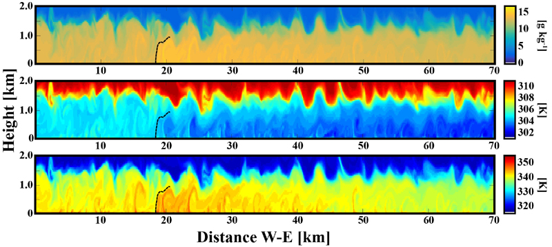
Water vapor mixing ratio, potential temperature, and equivalent potential temperature (top to bottom) from a preliminary simulation of an outflow airmass that evolved into a MAHTE. Note that the equivalent potential temperature maximum behind the gust front (dashed line) is collocated with higher water vapor mixing ratio and lower potential temperature relative to the ambient environment.