Objectives: To Know:
O1: how and why temperatures vary during a 24 hr. period.
O2: the formation and importance of inversions.
O3:how latitude, cloud cover, proximity to water, and elevation affect a location's
temperature.
O4:why wind affects human perception of temperature.
![]()
Did you Know?
![]()
Misconceptions:
M1: Coldest temperatures usually occur in the middle of the night.
M2: Venice, Italy, with its palm trees and year-round gondolas, is further south than
Minneapolis, Minnesota.
M3: Glaciers don’t exist near the equator.
M4: Hawaii's record high temperature is greater than Alaska's record high temperature.
M5 :One only needs to worry about hypothermia when it is snowing and
temperatures are in the thirties or below.
M6: : "Jack Daniels on a cold day is my warm friend—it feels sooo good going
down"
![]()
![]() O1: how and why temperatures vary
during a 24 hr. period.
O1: how and why temperatures vary
during a 24 hr. period.
During the day, the surface of the earth and the air above it, will continue to warm as long as incoming energy (mainly sunlight) exceeds outgoing heat energy from the surface. Heating of the air typically begins shortly after ________________ and generally peaks at ________________.
During the night, the earth’s surface cools by giving up more
________________________
than it receives-a process called ____________________________
Temperatures will continue to decline until about
_______________________
The coldest nights occur during the winter when the air is clear, calm, and
____.
![]() O2: the formation and importance
of inversions.
O2: the formation and importance
of inversions.
The lowest temperatures during the night and early morning hours are usually observed at the earth’s surface because
When the coldest air is at the earth’s surface, the air above is warmer and a radiation inversion exists.
Effect on pollution:
Effect on orchards:
Methods to reduce fruit losses:
| mixing | |
| heating | |
| encourage a freeze through spraying? |
![]() O3:how latitude, cloud cover, elevation,
and proximity to water, affect a location's temperature.
O3:how latitude, cloud cover, elevation,
and proximity to water, affect a location's temperature.
1. Latitude: generally, the lower the latitude the _________________ the average temperature. The ______________the lower the average temperature. Consider the roll of large ____________________.
Quiz question: Consider the map on p. 69. Why do isotherms (lines which connect points of equal temperature) over North America bend southward during the winter and northward in the summer?
2. Altitude
glaciers at the equator, Why?
Calculation: Use the the normal lapse rate to calculate temperature on top of Mt. Everest.
3. Cloud Cover
A cumulus cover by day would ______________________ a cumulus cover by night
would _______________________. In general high level (cirro-form) clouds
promote surface heating while lower level clouds promote cooling.
4. Land Water Differences
During the summer, humid climates tend to have lower daytime maximum temperatures and higher nighttime minimum temperatures than do drier climates.
Even though two cities may have similar average annual temperatures, the range and extreme of their temperatures can vary greatly. Consider Alpena and Portland, Oregon.
Climate information for Minneapolis and Portland. Keep in mind that Portland is further north. You choose which data set belongs with what city. Label the graph completely.
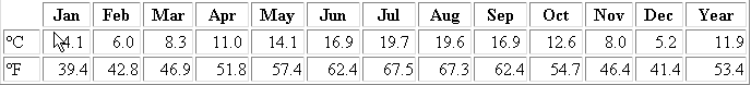
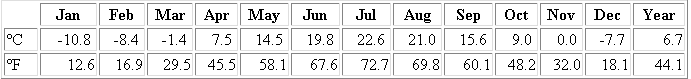
Source: http://www.worldclimate.com/
a. evaporation
b. transparency
c. specific heat: it takes 1 cal to heat 1 g or water 1 °C
d. ocean currents: Why Venice is warmer than Minneapolis, even though Minneapolis is further south than Venice.
continentality vs. marine influence: Hawaii and Alaska record high temperature is tied at ° because
O4:why wind affects
human perception of temperature.
The wind chill factor is a measure of the cooling effect of the wind on the human body. It does not relate to inanimate objects such as water pipes, etc.
Apparent versus actual temperature
Wind chill index
reading the chart
hypothermia
drinking and wind chill
![]()
Web Resources to Supplement this
Lecture
- HOURLY U.S. TEMPERATURE STATISTICS: high and low temperatures from across the contiguous United States.
- HOURLY U.S. CLIMATE STATISTICS FOR HEAT INDEX: where is it most miserable?
- HEAT WAVES/HEAT INDEX: NOAA explanations for heat wave associated dangers, how the heat index is computed, and how to best cope with heat related dangers.
![]()